Length: up to 5.5 miles depending on loop
Difficulty:
- easy
- moderate
Permitted Use:
About Dodge Point:
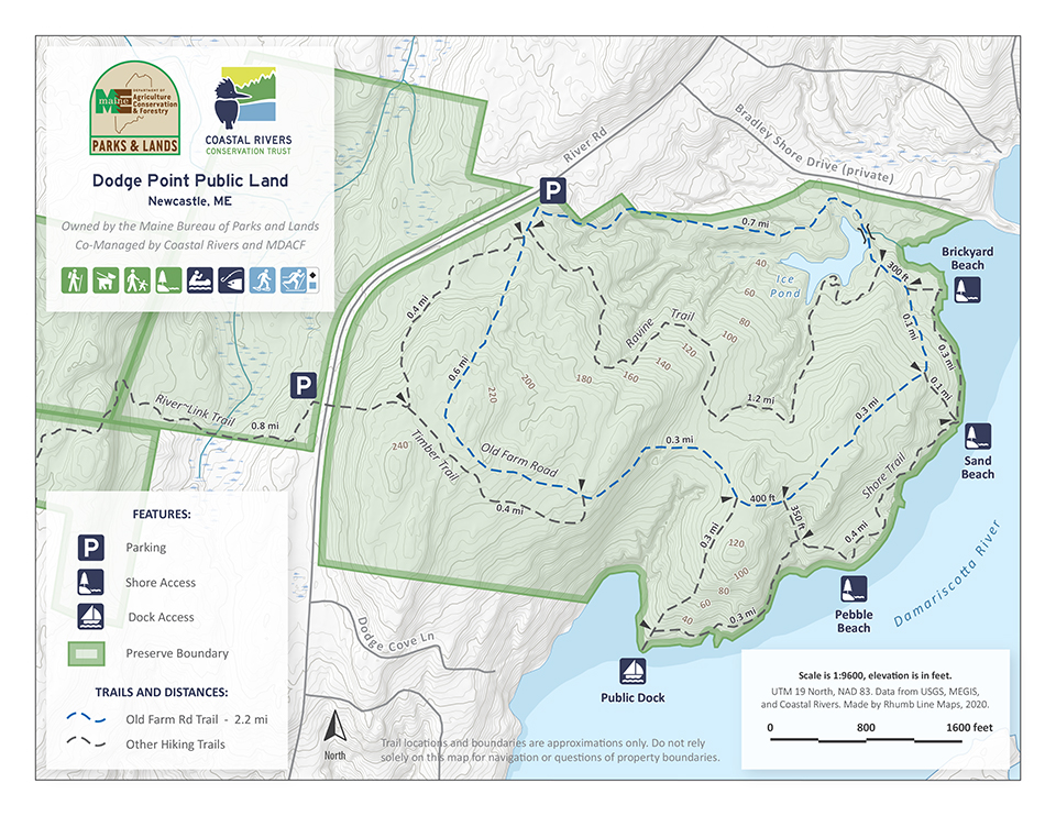
Dodge Point was once an award winning tree farm owned by the Freeman Family. The State of Maine purchased it in 1989, with help and funding from the Damariscotta River Association, the Maine Coastal Program, and the Land for Maine’s Future Program. Towering plantation red pine still dominate much of the forest and the State continues the longstanding tradition of careful timber harvest at regular intervals. Dodge Point boasts an extensive trail system and is the northeast terminus of the River-Link Trail. Coastal Rivers maintains a dock on the Dodge Point shore for public use. Dodge Point consists of over 500 acres with more than 8,000 feet of frontage along the Damariscotta River.
Managing organizations: Owned by the State of Maine, co-managed by the Maine Department of Agriculture, Conservation, and Forestry and Coastal Rivers Conservation Trust
Trail description:
There are 4 four main trails on the preserve. They are:
Old Farm Road Trail (2 mile loop, easy): The Old Farms Road Trail leaves from the parking lot and traverses the interior of the preserve. This trail is an easy hike along old farm roads used by farmers in the 1800’s and loggers in more recent times. It winds through a mixed growth forest with gentle sloes and a large stand of red pine. Along the way it passes many old stone walls, remnants of farmers’ property boundaries. There is also an ice pond off of this trail that was used by residents of the area during the winter for their ice boxes for cold storage prior to the introduction of electricity. Other trails branch from this main trial providing access to different areas of the preserve.
Ravine Trail (1.2 miles, moderate): The Ravine Trail bisects the preserve and offers visitors steeper and more challenging grades. Sighted along this trail have been fox, raccoon, deer, and an occasional moose.
Shore Trail (1.5 miles, easy): The Shore Trail spurs off the Old Farms Road Trail and follows the shore of the Damariscotta River. It is the most popular of the 4 trails. Hikers can access a sand beach and a pebble beach for swimming. Visitors can picnic on the river bank while observing several species of shore birds such as egrets, ospreys, herons, and eagles. Anglers can fish for striped bass, mackerel, and blue fish.
Timber Trail (0.8 miles, easy): The Timber Trail passes many stone walls and a mixed growth tree forest. From this trail the River-Link trails spurs off to access other trails that are not on this preserve, but that are open to the public.
Directions to trailhead:
From the north: Take the Newcastle exit off US Route 1 and turn left on Mills Road. Follow the road for 0.5 miles. At stop sign, head straight following River Road for approximately 2.6 miles. The parking lot and trailhead will be on your left.
From the south: Take the River Road exit (Snead’s Spur) off US Route 1 and turn right onto River Road. Follow River Road for approximately 2.5 miles. The parking lot and trailhead will be on your left.
Preserve guidelines
Please click here for guidelines to this preserve.
> Download the preserve map here.